Hurricane Ian strengthened overnight and will make landfall on Floridas west coast Wednesday as a powerful Category 4 storm, according to the U.S. National Hurricane Center.
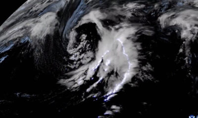
Satellite imagery shared by the National Oceanic and Atmospheric Administration shows frequent flashes of lightning in the outer bands of the cyclone as well as the eye wall. The clip was captured Tuesday while the storm was a Category 3, gathering strength in the southeastern Gulf of Mexico.
At 8 a.m. ET Wednesday, Ian was a Category 4 storm with maximum sustained winds near 155 mph with higher gusts, according to the National Hurricane Center. The agency said the eye of the storm is expected to cross over central Florida Wednesday night and Thursday morning.
The National Weather Service Tampa Bay on Wednesday morning advised residents along the southwestern coast to shelter in place through Thursday. The agency said to expect life-threatening storm surge and catastrophic flooding with 24 inches of rain in west-central Florida.
The storm will bring “catastrophic” storm surge along portions of Floridas southwestern coast, according to the National Hurricane Center. It is expected to weaken after landfall, but heavy ran will still cause widespread flooding.
Some parts of Florida are already experiencing localized flooding, and much of the southern part of the state is under a tornado watch until 5 p.m. Wednesday, according to the National Weather Service Tampa Bay.